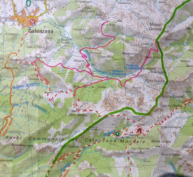
Here's a summary of the statistics for the day's hike:
- Distance: 12 km
- Total ascent: 1550 m
- Total descent: 235 m
- Time 7 hours
A photo taken of a small section of the map we carried for the northern section shows the route. Note that contour intervals are 50 metres.
 |
| Day one: Calenzana to Refuge d'Ortu di u Piobbu |
Here are the notes I made on my phone after the day's walk:
- steady climbing initially through open slopes of maquis and then lovely aromatic Laricio Pines. Excellent views back over Calenzana and Calvi. A brief stop at a col ( Bocca a u Saltu, 1250 m) then some traversing through more lovely pines. Some scrambling up through rocks - including one short sections equipped with chains. Lunch at a pretty open saddle with mountain views. A bit more ascending and then a traverse around a cirque to reach the hut which is situated on an open slope with excellent views. Time taken: 5 1/2 hours.
What the guidebook doesn't say is that there is a lovely little bar restaurant right at the start of the GR at the top of the town of Calenzana. There were a few other walkers fuelling up. We paused for a photo to mark the moment:
 |
| Keen as mustard!
We started walking at 7:15 after catching a taxi from our hotel in Calvi, which claims to be the birthplace of Christopher Columbus. Quite a few folks camped overnight in Calenzana to make an early start, and it was very early for a number of them. Apparently there was quite a bit of late partying, traffic noise and then people started getting up at about 3:00 a.m. Hmmm. Perhaps a bit nervous about the day ahead? Some of the folks we chatted with over the next couple of days were very unimpressed!
Here is an early glimpse back at Calenzana tucked away under the hill in the foreground:
Even at this late stage of the season the maquis - also know as macchia - still had lots of colour, was very aromatic with some of the herbs continuing to flower. Soon we passed the first of many beautiful Laricio Pines ...
... and the first mountains started to come closer. It's quite remarkable how suddenly one becomes engulfed in the spine of Corsica when one embarks on the GR20. We're on our way to the col on the right ...
... and here we are at the col looking back down at Calenzana, which is getting more distant:
Around through the col we caught or first glimpse of Calvi, which we were to see off and on over the next three days as we move higher into the mountains:
A little further on after passing through a gorgeous bit of forest we arrived at a section that involved a bit of traversing and scrambling over rocky ground. If you click on and look closely at the photo below you should be able to pick out six hikers. Some of them are engaged in a section with chains.
|
Not long after the rocky section above we arrived at a lovely spot for an early lunch where a few other hikers were recovering from their exertions:
A couple hundred more metres of climbing brought us to a huge cirque, across which lies the refuge on a small shelf overlooking a west-facing valley. A liaison track provides access to the outside world, which the guardians of the refuge use for reprovisioning. Here is a look back around the way we came around a series of lichen-coloured slabs ...
Upon arriving at the hut, one's attention is readily drawn to the blackboard advertising food and drink, and then to the sign with the name of the hut and its altitude (1560 m):
Under the sign, enjoying the sun was one of two resident dogs ...
... and around the side one of a number of horses used to bring up provisions was hanging out ...
At this particular refuge the horses roamed freely, and were as likely as not to leave an aromatic present adjacent to one's tent! You might notice the two satellite dishes on the roof. I think one was for the internet, as it is possible to book the refuges over the internet - some of the time at least!
I don't have a photo of the toilet block but it is about 60 metres away behind where this photo is taken. Plenty of fresh - and I mean fresh - water to wash away the sweat from what was a pretty warm and strenuous day.
We got the tent up in quite a nice spot just below the refuge (ours is the green one on the left closest to the camera) ...
... with a lovely view out the window across the shelf below and the mountains and coast towards the west:
We had a few hours to relax before dinner. Di reckons this refuge had the best food, the mainstay of which was an excellent lentil and sausage stew. It also fed us nice and early: 6:00 p.m. which was a rarity and much appreciated because it left a couple of hours of daylight to enjoy after dinner. And that's pretty much it for Day One on the GR20. A strenuous but not overly difficult day, which we were pleased to finish well within the notional time from the guidebook. We felt encouraged that we just might be able to survive the hike. The next day was billed as a difficult follow-up to the first, significantly shorter and with less altitude gain, but lots of scrambling and only half an hour less time suggested for its completion.
We looked forward to the challenges ahead ...


No comments:
Post a Comment