The GR20's Queen Stage?
This was perhaps the most spectacular day on the GR20, hence the heading I have proposed. Here are a few brief extracts from Paddy Dillon's introduction to this stage: "a tough day's walk, especially after the exertions of the first day. It involves walking round a rugged shoulder to reach a valley ... climbing to the Bocca Piccaia (where) the view is magnificent ... full of spires and towers of rock. The route traverses round the flanks of the mountains ... it becomes quite difficult with numerous short rocky ascents and descents. There is another chance to enjoy exceptional views before a long, steep and stony descent to the Refuge de Carozzu. (If this day's walk sounds too tough, refer to the next section for the low level alternative.)"
Statistical summary:
- Distance: 8 km
- Total ascent: 750 m
- Total descent: 1050 m
- Time: 6 1/2 hours
Here's the route on the map:
Before we hit the trail I took this snap from our tent site. If you click on the photo to expand it - and are still sharp-eyed enough - you should be able to make out campers packing up and readying themselves for the day ahead:
 |
| Another morning in the mountains ... |
The day started with a rising traverse through some lovely birch forest which was just starting to turn colour. We were somewhat surprised to see such a concentration of deciduous trees at these altitudes (over 1500 m), but then we're not very familiar with hiking in these regions. In the photo below, just ahead of Di is a young Irishman who is walking on his own. There were a number of solo hikers, but this was not really a safety issue because there were so many people on the trail.
 |
| We love walking in the early morning light |
 |
| Anticipating the sunshine ahead ... |
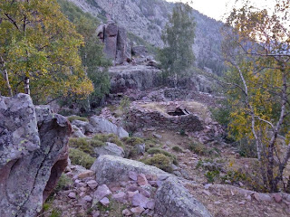
Just before leaving the forest we came across the ruins of an old shepherd's hut on the flanks of a mountain, situated at the head of a valley which provides access to the world below.
 |
| Autumn is on the way ... |
The walk through the forest provided a lovely prelude to the spectacular hours ahead. This is one of the first views that greeted us shortly after the previous photo was taken:
 |
| Stunning spires, mountain massifs and dramatic gorges everywhere ... |
On into this beautiful, chaotic landscape we went. Di leads on across the shoulder of a mountain towards who knows what ahead. We were constantly amazed and often surprised throughout this stage - and during the next few days - as to where the route led us. In the panorama below Di can see where we are going as there is a hiker ahead ...
 |
| Around the shoulder ... and then where? |
A brief pause on the ridge ...
 |
| A tiny figure tossed on a sea of rock |
... before more sidling and then, surprisingly, a gradual traversing descent before heading steeply down to a gap on the next ridge ...
 |
| A bit of sunshine before heading back down into the shadows |
After the descent and around the next ridge there was another bit of descending through a loose and rocky chute then more traversing across a gully and some very prickly vegetation. At the point where the next photo was taken we have just missed a hidden slot and have to reascend the track about 10 metres. (You can see a couple of trail markers above.) If you look closely at the photo you should be able to see five hikers behind us, coming down the chute and across the gully.
 |
| Tracing the way through |
This day and the next few reminded us very much of hiking in the Western Arthurs - and, to a lesser extent, the Eastern Arthurs - in Tasmania's Southwest National Park, but on a much bigger scale. The geology is different: The Arthurs are made up of Quartzite while all but the southern fringe of Corsica is a mountain of Granite rising up off the floor of the Mediterranean Sea. It wasn't so much the mountains themselves but the amount of scrambling and intricate route-finding in both places that really struck us.
Around the next ridge we were presented with another view of stunning spires and we wondered where we were heading next ...
 |
| Lots of potential for rock climbers to make first ascents! |
The route weaved around a ridge and then across towards a peak. You can see where the track zigs and zags up a vegetated scree slope towards the shoulder ...
 |
| Great views of the route ahead |
The Bocca Avartoli leading through a small gap provides the key to getting around the ridge ...
 |
| A beautiful patina of lichen coats much of the rock |
... and then there is a little scramble up through a slot ...
 |
| It's not as steep as it looks! |
Seemingly against all odds, tucked away in a shady, sheltered and damp spot high on the mountain side was a pocket of vegetation where this Foxglove was still flowering ...
 |
| Delicacy finds its place |
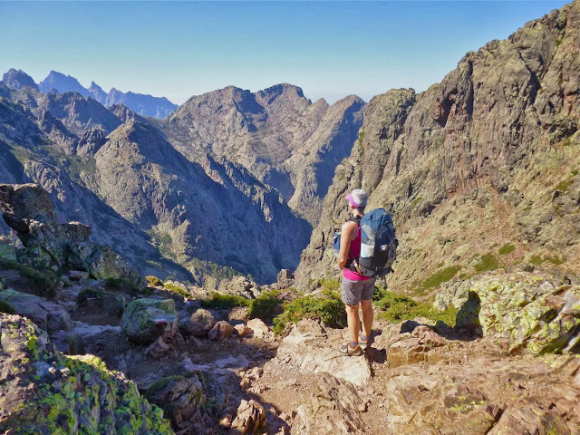
... and then we were back in the sunshine on a shelf looking out at a stunning vista ...
 |
| You've seen this picture before! |
... before entering a steep and loose descent ...
 |
| Watch your feet! |
... which led to the head of a large cirque, another magnificent vista ...
 |
| Fancy a short side-trip? |
The track continued around the shoulder to the left and around to another shelf which held some small Laricio Pines and one real beauty, with a view through to another cirque with some fantastic spires. The route will take us down into that cirque beside those spires.
 |
| Just wonderful walking! |
Eventually we were on the descent to Refuge Carruzo. Again, deciduous forest reached high up into the cirque leading us to believe that we were closer to the refuge than was actually the case ...
 |
| Down into the forest we go |
It was a lot farther down than we initially thought but we hadn't actually done much descending up until this point. Most of the day had been spent traversing, either gradually climbing or descending with the occasional short steep section. It had been hot work mostly out in the sun at elevations between 1500 and 1800 metres and we'd been drinking lots. We were almost at the refuge in the next photo where Di is drinking the last of her water ...
 |
| Thirsty work |
The notes I made a little later as we were having lunch and a beer on the sun deck of the refuge says "A long and loose descent brought us to the refuge exactly five hours after leaving Piobbu. Quite an unrelenting day for old knees but absolutely stunning terrain".
The refuge is tucked into quite an idyllic spot where they can make good use of the sun's power ...
 |
| Surrounded by Granite |
Once we'd set up the tent at pretty much the exact spot where the photo above was taken we went around to the front of the refuge to see what was on offer for lunch. They had plenty of menu boards up from which we could choose ...
 |
| What's for lunch? |
By the way, here's a chance for one of my diversions: if you look closely at the "RGE DE CAROZZU" sign, you will notice that it gives the altitude as 1270 metres. That's exactly the height of Mt Wellington, which sits proudly above our home city of Hobart and is a haven for hikers, mountain bikers and rock climbers. So far we've avoided the scourge of a cable-car despoiling the peace and tranquility of recreating on "The Mountain".
Back to Corsica and the GR20: the guardians of Refuge Carozzu were probably the more entrepreneurial of all those looking after refuges and bergeries along the route, having quite a selection of goodies to eat and drink - perhaps partly because access to the outside world was reasonably easy via a short liaison trail. They even catered for those with sore muscles - or who might be anticipating sore muscles with massage oil for sale, as well as essential oils and bug spray:
 |
| Massage anyone? |
Quite clever, and later on the traverse I was really wishing we'd bought a bottle of the massage oil as sadly none of the other refuges had thought to do the same.
Yet again we had a tent site that gave a great view. Here's a photo of the same peak that is in the background of the photo with Di drinking the last of her water, from a slightly different angle ...
 |
| Looking out through the tent window at Refuge Carozzu |
There is a lot of hype around the GR20, and I'll say at this point that we ran into many folks who perhaps shouldn't have been on the route but wanted to knock off the "toughest grand randonnée in Europe". A lot of up and down, pretty rough paths requiring a fair bit of agility and exposed scrambling in places combine to make for a very challenging adventure hike. Despite a lot of experience in varied conditions we weren't sure we'd be able to finish the route ourselves when we set off from Calenzana. Now we were starting to feel more confident as we'd completed the stage an hour and a half quicker than the suggested time in the guide (after also being quicker on the first day, despite pacing ourselves up the "unremitting" ascent).
A couple of very hard stages loomed in front of us. If we could get through those we thought we'd have a chance of completing the journey. However, with knees getting a little sore from the long descent to Refuge Carozzu we were still uncertain whether our bodies would hold up for another thirteen days. Anticipating another tough day ahead we hit the sack early.
